Le Réseau Alpin des Espaces Protégés

|
Under this link you can download the first newsletter of the HABIT-CHANGE project. This issue is dedicated to the project work until the mid-term. Since dissemination of results will become more important in the second half of the running time the upcoming issues are going to focus on that. You are welcome to distribute this e-mail to colleagues, who might be interested in subscribing to the newsletter too. We wish you a pleasant reading! PS: If you do not wish to receive further e-mails regarding our newsletter please send an e-mail with the text 'unsubscribe' back. |

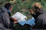
During an international workshop held in the Chartreuse Regional Park (France) from 13-15 October 2011, more than 30 experts from science and parks management across Europe discussed the role of mountain protected areas in regional development.
The discussion was based on the input of selected experts from Germany, Switzerland, Norway and Austria who have a well recognized reputation in the area of protected areas. According to the experts´statements possible economic issues of protected areas are mainly linked to added values generated by park tourism, as proved by a large range of scientific studies. In future, research has to investigate more than so far on further economic opportunities generated by parks (ecosystem and cultural services etc.), on the involvement of regional stakeholders (perception, acceptance, multi-level governance etc.) and on regional change management (adaptive measures, scenarios in the light of climate change, demographic change etc.).
The workshop was jointly organised by ISCAR (International Scientific Committee on Alpine Research), ALPARC (Network for Alpine Protected Areas) coordinated by the Task Force Protected areas of the Permanent Secretariat of the Alpine Convention and NeReGro (Network Regional Development and Protected Areas). Major results will be published 2012in eco.mont - Journal on Protected Mountain Areas Research and Management.
More information: http://www.iscar-alpineresearch.org/workshop2011/
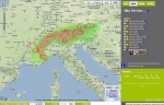
Under the umbrella of the ECONNECT project , during three years, 16 international partners worked towards extending and protecting the Alpine ecological network. The results of their work were presented in Berchtesgaden, Germany, from 26th to 28th September 2011.
Ecological connectivity, namely the way how habitats are physically connected and the level of ease for movement of the species, is a theme of real topical interest, since it is fundamental for an effective conservation of biodiversity: many species and most of ecological functions, in fact, require much larger areas than those available within park boundaries.
Within the ECONNECT project , since 2009 ALPARC and 15 other partners analysed the issue of ecological connectivity in the Alps both from functional (presence of barriers such as motorways and dams) and legal (differences and contradictions among different legislative systems which could limit the creation of an ecological network) points of view.
A solid methodology to identify the key corridors and physical barriers, even “invisible”, which could threaten the connectivity, has been developed. It has also been created a useful mapping tool to visualise barriers and corridors, which can illustrate the concept of ecological connectivity for policy makers and planners. In addition, in seven pilot regions solutions for enhancing connectivity were carried out in field.
The results of this experience, maturated in three years of work, were presented at the Final Conference of ECONNECT, which took place from 26th to 28th September in Berchtesgaden (D). The conference had great success from the point of view of both participation and possible future developments.
Indeed, it was the occasion to suggest innovative ways of protecting our Alpine natural heritage and provided a forum for discussing ways to place ecological connectivity firmly on the European political agenda, thanks also to the introduction of recommendation policies for politic decision-makers about how to convert degraded and fragmented alpine ecosystems into a healthy ecological network.

The subject is of great topical interest: how can we assure a larger effectiveness of the alpine protected areas’ management measures? How can we monitor the effectiveness during the time?
An increasing number of protection authorities as ministries and local communities request to protected areas managers a veritable evaluation, in terms of effectiveness, of their management measures. Some large organisations, such as IUCN and the Council of Europe (European Diploma of Protected Areas ), dealt with this topic at the level of protected areas.
This project gets in the framework of the meetings and reflections of the working group of the Alpine Network of Protected Areas (ALPARC) concerning the topic of management measures evaluation by comparing their effectiveness at international level. Thanks to the support of the Swiss Federal Office for the Environment (FOEN) and the collaboration with the Swiss Parks Network , the Alpine Network of protected Areas could develop a first version of a catalogue of indicators addressed to protected areas managers. This catalogue (CIME_1), with a first selection of 25 recommended indicators, aims for being a simple and functional application tool.
Each one of the 25 recommended indicators is described in a factsheet where amongst other things are specified:
The suggested approach, which relies on methodologies standardised at international level, has been developed within exchanges and needs expressed by managers themselves during different meetings, in order to create an easy, pertinent and effective tool! In addition, a steering group, constituted by representatives of FOEN, Swiss Parks Network, Swiss Academy of Sciences , Entlebuch Biosphere Reserve and ALPARC, permitted the progress and the summary of scripts pursuant to the workshops.
CIME_1, available in English and in the 4 alpine languages, has to be tested so that it is possible to proceed on its evaluation and improvement.
Are you a manager of an alpine protected area?
Don’t hesitate to use it in your ordinary practices, as both evaluation tool and log.
Send us your opinion and remarks! They would be very useful to refine the catalogue!
Based on interviews with 21 alpine protected areas, the report “Renewable energies in Alpine protected areas” shows the conflicts between the protection and the use regarding the production of renewable energies as well as possible strategies. The study has been elaborated by the Swiss Academies of Arts and Sciences (SAS) with the support of the Alpine Network of Protected Areas (ALPARC) and has been funded by the Federal Office for the Environment (FOEN).
In the parks, which have been analysed, the majority of conflicts is caused by wind and water power. Regarding the use of water power, the more severe legislation will reduce the potential for conflicts in particular what concerns residual flow, hydro-peaking and river dynamics. Furthermore, the increasing demands lead to new conflicts. Wind turbines generally encounter resistance from landscape conservation organisations. The potential conflict of photovoltaic and biomass is currently lower; however, it will probably grow with the increasing demand for renewable energies.
There is no remedy that applies to all parks, it’s depending on the potential of conflicts and the need for action varies. Thus, only some of the parks would prefer stricter rules and the question about energy targets or concepts are judged differently. Regardless of the path that a park chooses to follow, it will be unavoidable to deal with the topic.
The report, available in a trilingual uncutted version and a concise version in German, French or Italian, can be downloaded at:
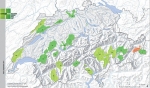
A happy day for the Swiss parks: 8 parks got the label “Parks of national importance” by the Swiss federation.
In December 2007, the legal basis for the creation of new parks came into force. Therefore new parks next to the Swiss Nationalpark , which exists now for almost 100 years, were created.
Next to the wildness park Zürich-Sihlwald , which won acceptance as a nature discovery park, the UNESCO biosphere reserve Entlebuch and Val Müstair and as well the region Thal were accepted.
The following eight parks will start their operational phase fort the next 10 years:
• Landschaftspark Binntal VS,
• Parc régional Chasseral BE/NE,
• Naturpark Diemtigtal BE,
• Parc Ela GR,
• Naturpark Gantrisch BE/FR,
• Parc naturel régional Gruyère Pays-d’Enhaut VD/FR,
• Jurapark Aargau AG,
• Naturpark Thunersee-Hohgant BE (on condition that the municipalities accept the project).
Further information, you can find in the press release (in German, French and Italian) of the Swiss Parks Network .
or in the link: http://www.bafu.admin.ch/
Contact: Andreas Weissen, general manager of the Swiss Parks Network. Tel. 0041 79 549 92 41
source: Swiss Parks Network
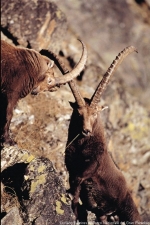
At the beginning of the XX century, the ibex, an animal proper to the Alps, was threatened with extinction because of the high hunting pressure. Only the population of Gran Paradiso managed to survive, thanks to a law enacted by the king Vittorio Emmanuele II of Savoy.
The 8th May 1911, in the peak of Rappenloch, in the Weisstannen valley (SG) the first specimens have been released. These ibexes have been illegally imported from Italy and formed a stable colony afterwards.
100 years later, Switzerland celebrates the anniversary of this success. Nowadays, in fact, the ibex started to populate vast alpine regions, representing the best result ever achieved on a worldwide scale in the field of re-settlement of species next to extinction in their environment.
The 6th May 2011 in Weisstannen, the centenary of the reintroduction of ibex has been opened with an official ceremony. During the year span numerous organisations and organisms, among which the association Pro Natura , the Federal Office for the Environment , the Swiss Society of Fauna biology , organised a great number of events and excursions dedicated to ibex in all Switzerland.
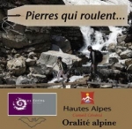
The Ecrins National Park created, with the initiative of the Centre of Alpine Orality (General Council of Hautes-Alpes ), an archive of documentaries and sound creations, recorded mainly in the alpine massif. These archives, a contribution to memories of the territory, are available on the webpage “Pierres qui roulent ”.
This webpage offers you to listen to sound creations, documentaries, stories and sound effects of the alpine region. All recordings are produced giving a voice to those who live the mountainous life every day.
Further infomation (in french) at:
The ECONNECT Final Report is out and is ready for download in the section below.
The decision was taken by the region of Geneva and the local Swiss and French municipalities: from April 2011, the road between Mategnin (Meyrin / GE, Switzerland) and France will be removed through populations of amphibians!
The Nature reserves "Les marais des Crêts " and "Les marais des Fontaines", where you can find many species pertaining to this class, of which 70% are on the IUCN Red List of threatened species , in an area of 15 hectares, will again reconnected for the development of flora and fauna. The permanent dismantling of a road happens for the first time in Switzerland. It allows the creation of a large nature reserve, which contributes to the reconstruction of an ecological network.
More information on: http://www.espacemategnin.ch/ and http://www.pronatura.ch

The project “Equilibri Naturali” is designed to bring children closer to nature.It focuses in particular on addressing current social issues such as obesity, short attention spans and dependency on television and computer games by promoting outdoor experiences through creative activities and a more relaxed pace of life.
In addition to the opportunity to teach children about sustainability, the outdoor activities help to create a sense of "belonging" to an area. The activities allow children to rediscover the value of interacting with others (playing games, shared outdoor adventures) whilst also improving the way that they learn.
The Natural Balance programme was developed by the Monti Sibillini National Park in Italy and has been implemented by AIDAP (Italian Association of protected area directors and staff). Many Italian protected areas have signed up to the project, including the Belluno Dolomites National Park, which is very actively involved.
Details of the Natural Balance programme and events are available online at the Italian protected areas website (www.parks.it ).
For further information:

After two and half years of working on the ECONNECT project, innumerable meetings with local stakeholders, project partners and experts, and the long and complex process of developing a methodology, mapping and planning the activities, the project is entering the final phase: implementing the connectivity measures.
The pilot regions have chosen which actions they will implement in order to demonstrate that, after a process of planning and coordination with local stakeholders, it is possible to improve connectivity between our most valuable habitats, which are often also the most fragile.
Naturally the scope of these activities is limited by the funding available, but they do prove that a structured planning process and awareness-raising can produce results.
ECONNECT is essentially a planning project and has trialled a fairly sophisticated methodology (Joint Ecological Continuum Analysing and Mapping Initiative – JECAMI, analysis of potential Alpine habitats for certain species and of the fragmentation of the Alpine region). It also engages the stakeholders who are essential to the creation of an ecological continuum in the Alps.
ECONNECT has certainly achieved its aims. The priority now is to draw conclusions based on the findings of the ECONNECT project, notably strategic recommendations on implementing measures and integrating the ideas into Alpine land management policies with a view to facilitating genetic exchanges and improving the potential for conserving Alpine biodiversity.
We have six months left to achieve these aims, as the project has been extended to November 2011.